Release 14.01
The geOrchestra community are pleased to announce the immediate release of version 14.01. Since the June 2013 release 151 evolutions took place, emphasising on stability, analysis, and data sharing.
This release was once again achieved by the community of users. They are spotted on the demo site, which opens on a global map of the geOrchestra community members. How about paying them a visit?!
Features
 geOrchestra
14.01 includes the following new features amongst the 35 improvements and 116 issues addressed processed. As shown
by Ohloh the
project has seen a sustained activity since the last release.
Multilayer querying
A multilayer querying mode was added to the main toolbar. This mode enables map querying and returns the outcomes as a table for each layer displayed. Simple and multicriteria queries remain available through the layers' dedicated menus.
![multiple getFeatureInfo, fév. 2014 [screenshot]](/public/screenshots/14.01/multiquery.png)
Extractor addon
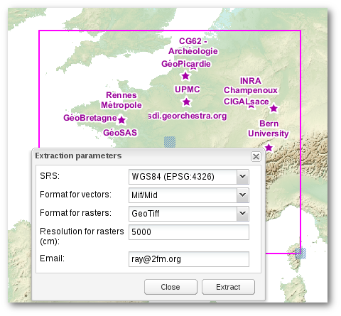
Makes direct download of all the data currently displayed possible without moving to the extractor's user interface. The user state their coordinate system, output format, raster resolution where applicable, email address to send the data to, and geographical extent. Separate download for each dataset remains an option with the layer's "action" menu. As a reminder the extractor module is designed to organise and download the data from the geOrchestra SDI or third party services on-demand.
This functionality is an optional addon users need to activate in their profile prior to using it.

Persistence of OGC documents
Users' compositions: Web Map Context (map composition) and Styled Layer Descriptor (data symbolisation) are stored in a database. Each document has its unique URL, visit counter, and reference to its creator.
Menu "Share"
A new "Share this map" action illustrates the pertinence of OGC documents' persistence:
A map may be
- kept as a permalink
- modified by a third party as to compose a new map with a bespoke SLD analysis
- sent to alternative viewers
- sent to third party applications or shared on social networks the admins select in the viewer's settings.
Thus from a single map one can design as many consumption modes as they wish: from a basic viewer to the specialist's application.

Lightweight viewer
A lightweight viewer powered by Openlayers3 and jQuery mobile was tuned for the occasion. It interacts with the "Share map" action to forward a map context on a mobile phone or tablet PC. The lightweight viewer queries the capabilities to join a map its legend, titles and data description, product credits, and keeps a link to metadata. One can still switch back to geOrchestra's default viewer for a change in map composition and thematic data analysis. The lightweight viewer is available in English, French, Spanish, and Russian.
Data editor
GeoServer is one of the few OGC service providers offering a fairly complete data service (WFS 2.0). Every vector data delivered by GeoServer is remotely editable to whom is granted permission. This capability was previously exploited through QGIS or a dedicated geOrchestra application.The use of two applications to view and edit data made the editing process complicated.
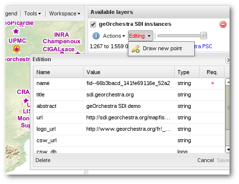
The viewer in geOrchestra now includes distant editing for all vector data. Whence a piece of data is toggled to editing objects are selected on-the-fly. One click makes the editing form active. Geometry and attributes may then be modified. Each modification is immediately propagated onto the map with its current style.

Layer order
The viewer accounts for opacity as stated by WMS services. Layers deemed 'opaque' (i.e. covering) are placed in the background with a progressive zoom adapted to basemaps. Attributary data are displayed foreground without a zoom effect.
OpenLS location
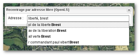
In addition to GeoNames location (via geonames.org which now requires a registration) and Referential (on existing WFS layers) previously available a new addon now provides search through the OpenLS service (for compatibility with other SDIs as France's IGN GeoPortail). We are now looking for freely available worldwide OpenLS services to power the default geOrchestra configuration.

Managing permissions
GeoFence is an advanced permission manager for GeoServer. GeoFences makes the fine-tuning of data access and permission possible by setting layer-specific geographical and attributal criteria as well as by user or group.
Security
ArcGIS clients are detected and are attributed a specific authentication filter to grant access to protected data
The embedded GeoWebCache tile engine does security checks on the underlying GeoServer WMS providers. WMS-C, TMS and WMTS layers are now protected though GeoServer or GeoFence permissions.
Notice to admins
Prior to upgrading, please read release notes. Please note the geOrchestra databases were reorganised: every module now store their data in a single PostgreSQL base segmented into schemas. However the admins keep the option to spread the data over several bases.
On the community's side
SDIs in action
We are delighted to introduce you the SDIs which went online since last release:
- https://www.geopicardie.fr/, the spatial data infrastructure for Picardie, France
- https://www.cigalsace.org/, the spatial data infrastructure for Alsace, France
- https://www.craig.fr/, The spatial data infrastructure for Auvergne, France
- AMUPNOR IDE, Matagalpa, Nicaragua. A geOrchestra representative had a chance to visit them!
geOcom 2014
Following the success of the 2013 edition, we hope to share with you all these novelties and together discuss the forthcoming ones at geOcom 2014, which is expected to be organised in May or June.
Special notice
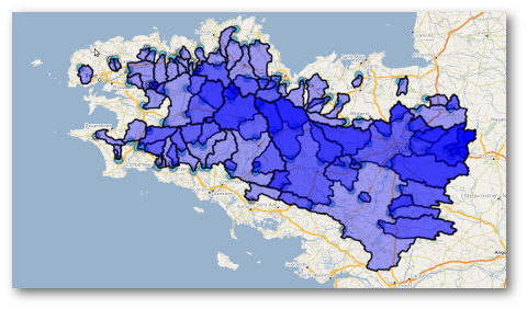
Finally we would like to thank team géoSAS from INRA+agrocampus Ouest for their enduring participation in the geOrchestra community. This research team was awarded in October 2013, the second prize of visualisation in geomatics at the International Festival of Geography, Saint-Dié-des-Vosges, France, for addon Watershed (a dynamic catchment delineation using OGC Web Processing Service) powered by geOrchestra.
 example: 109 watersheds
processed from an outlet layer
The addon and its service are in production, SDI GéoBretagne uses it on a daily basis (viewer > tools> manage tools). This contribution from the GéoSAS team completely relies on the philosophy an architecture choices which keep the community moving forward and make geOrchestra a free, open, interoperable, and cutting-edge SDI.